Benton MacKaye Trail Thru-Hiking Guide
A comprehensive guide to backpacking the Benton MacKaye Trail
Home > Trip Reports > Thru Hikes for Working People
June 11, 2024
The ~300-mile Benton MacKaye Trail (BMT) is a roughly paralleling route of the southernmost Appalachian Trail farther to the west, and bears the name of one of the founders and visionaries of that more famous route. It shares a southern terminus with the AT on Springer Mountain in Georgia, and the northern terminus is the Big Creek Trailhead in Great Smoky Mountains National Park, a few miles from the AT crossing in Davenport Gap.
It traverses long ridgelines and is seldom traveled, with few options for easy resupply. The BMT is rugged and remote, making it, in my opinion, far more challenging than the paralleling AT. A definite gem of the Wild East!
I hiked it southbound (SoBo) in late October/early November 2020 with a partner. We were lucky enough to enjoy a great deal of autumn color, even though it was unusually warm. Our hike was somewhat interrupted by a late-season hurricane that forced us to double zero in Blue Ridge, Georgia, in a hotel with no power!
Distance: 287.6 miles
Days: 14-30
Elevation gain/loss (SoBo): 56,808′/-54,682′
High point: Mount Sterling, 5,842 feet
Best season: Spring or Fall
Permits: Only for the 93 miles in Great Smoky Mountains National Park
Difficulty: Strenuous


This story may contain affiliate links, which help fund our website. When you click on the links to purchase gear, we may get a commission. This allows us to create reader-supported, objective gear reviews, independently selected by our editors — without costing you an extra cent. Thank you for supporting our work and mission of outdoor coverage for every body! Learn more.
Background

The Benton MacKaye Trial (BMT) is named for one of the driving forces behind the creation of the Appalachian Trail.
The Benton MacKaye Trail (BMT) extends between the northern end of the Great Smoky Mountains and the summit of Springer Mountain in Georgia, and is a less-traveled alternative to the southernmost section of the Appalachian Trail (AT). For most hikers, Springer Mountain is famous as the southern terminus of the Appalachian Trail. Few people know of its sister trail, which also starts there.
MacKaye was one of the driving forces behind the creation of the Appalachian Trail. This paralleling route–one-third of which is in designated wilderness– travels through the untrammeled ranges primarily west of the AT and bears his name. Some sections of the BMT were his original proposed routes for the Appalachian Trail corridor. 95% of the trail is on National Forest or Parklands, 5% is privately owned, and 100% is land traditionally stewarded by the Eastern Band of Cherokee Indians (Tsalagiyi Detsadanilvgi).
Highlights

The BMT traverses six wilderness areas.
Travel through six designated wilderness areas: It’s rare in the East to transit multiple wilderness areas in one trek. However, the BMT traverses a gigantic swath of land protected with the highest level of restrictions. This gives the trail a decidedly wild feel that is a real treat in the heavily impacted Appalachians.
Trek nearly 100 miles through Great Smoky Mountains National Park (GSMNP): While GSMNP is the most heavily visited National Park in the US, its backcountry is managed as wilderness. The Benton MacKaye Trail takes you through seldom-visited corridors where you will forget you’re in a crowded park.
Cross the Swinging Bridge over the Toccoa River: This engineering feat is the longest span bridge in Georgia, measuring 260 feet. It’s a picturesque attraction capable of withstanding the Toccoa’s frequent powerful floods.
Solitude: Forget the crowds and find real solitude on the Benton MacKaye. During our hike we saw only a handful of other thru-hikers. The BMT has seen fewer all-time route completions than the number of hikers that start the AT each year.
Challenges

Resupplies typically involve long walks or hitches into towns, which is a challenge of the BMT
Infrequent Resupply Locations: While the BMT crosses many roads, resupply options are limited and usually involve a hitch or long walk on a paved road. However, several businesses have historically held mail drops for hikers, which can make the carries more manageable.
Elevation Change (sometimes steep): Like the AT and other trails in the Appalachians, the BMT is often a steep footpath. Erosion can make these grades even more challenging. Even when the elevation change is not significant, it is frequent.
Weather: There are a lot of potential challenges weather-wise in this region. Winters are cold and snowy (especially at higher elevations) and winter storms can make for a lot of downed trees in the spring. Summers are hot and humid, and ticks and other insects are a problem. Summer and early autumn are also hurricane seasons, and this region may receive periods of heavy rain as a result.
Lack of Shelters and Established Campsites: Aside from the national park, all camping is at-large. While dispersed camping makes for a more wild-feeling experience, it also means finding a campsite can be challenging. More than once we were caught in areas without good options at the end of the day. Planning ahead by studying your maps or the FarOut waypoints can make this easier.
Safety: The flip side of solitude and remoteness is decreased safety due to other trail users being present. Cell service is infrequent, so you shouldn’t count on it in an emergency. Be sure to have a contact person at home with access to your itinerary and instructions for contacting land management agencies if you’re overdue. Consider packing a satellite device or personal locator beacon for safety, like the ones we’ve reviewed in our Best Satellite Messengers and Personal Locator Beacons guide.
Best Season
While you could enjoy the Benton MacKaye Trail year-round, it is best hiked in late fall or late spring to avoid ticks and mosquitos. Summers are hot and humid, insects are plentiful, and there is increased potential for encountering venomous snakes. Winters can range from mild to truly frigid, with deep snow depending on elevation and that season’s weather patterns.

November and April typically are the best months to hike the BMT, weather-wise.
Hurricanes are not unusual — a late-season one hit us while we were on trail — so avoiding June through the end of October is recommended, with September being the peak hurricane month. November and April are the best months to skirt most weather issues.
Difficulty and Skills
Navigation
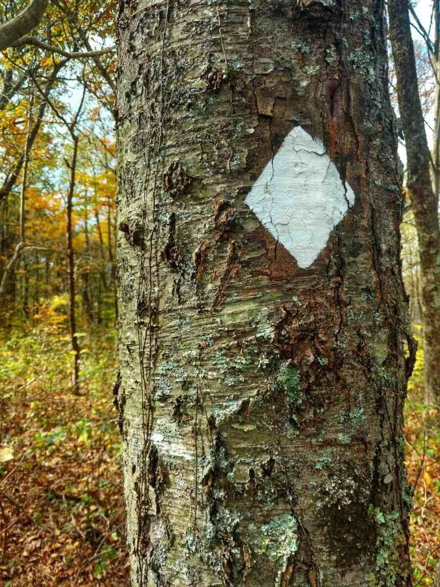
Navigation is straightforward. The BMT is marked with white diamond blazes throughout its length. There are also wooden signs at most junctions. I recommend using the FarOut App to handle potentially confusing junctions.

The BMT is marked with white diamonds.
Elevation Gain & Loss / Terrain
The trail itself is reminiscent of the parallelling AT, with similar grades and footing that is often rocky and rooty. The BMT does not have any technical terrain, although there are some areas that are eroded and can make for awkward rock steps or very steep grades.
As is typical in the Appalachians, there are many short ascents and descents which make for tiring travel. Switchbacks are rare, so expect to go straight up and straight down many of the mountains. Quite a few old roadbeds are utilized, which provide reprieves from the more angular singletrack.
Permits
The only part of the Benton MacKaye Trail where permits are necessary is in the Great Smoky Mountains National Park. You will not need to pay an entrance fee. However, you will need permits to camp. Within the park, camping is allowed in designated campsites and shelters only. You can obtain a permit up to 30 days before the first day of your itinerary.
If you intend to leave a car at the northern terminus, you will also need a parking permit. You can read more about that here.
Route Summary
Great Smoky Mountains National Park
Our hike began with a strenuous climb up into the Smokies, reaching the trail’s highpoint – Mount Sterling – at 5,842 feet. We traveled long ridgelines through the park and enjoyed frequent views of the Pisgah National Forest and the park's central spine, where the AT runs. Both of us had hiked the AT prior, myself three times, and so it was fascinating to view it from a new vantage.
Despite hoping this would be an easy hike, we discovered we’d accidentally booked our Smoky Mountains permits 28 miles apart each day. Our packs were heavy with shoulder season gear, but we hoofed it early and sometimes into the dark to reach them. It was a strenuous start to what was supposed to be our vacation! Little did we know that the Smokies would be the easier part of the trail.

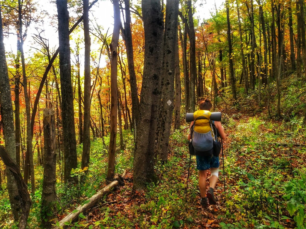
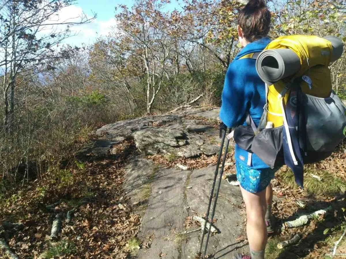
The BMT is beautiful, biodiverse, and rugged in some areas.
Joyce Kilmer Wilderness
North Carolina is endowed with incredible mountains and biodiversity. It’s also rugged beyond belief in some areas. As we discovered, these areas are frequently located along the BMT.
The terrain through the Joyce Kilmer Wilderness was typical Appalachian style: more roots and rocks than tread and nearly vertical. However, our reward came in views of the rolling beauty of the southern Appalachians all along our ridgeline walking. We enjoyed the daily challenge on this route.
Borderlands: Tennessee and North Carolina
The weather was warmer and more humid than expected throughout the first week on trail, although that would change drastically soon enough. Shoulder seasons are the most difficult to prepare for since the weather can shift from one extreme to the next within a short period of time. As we lugged our heavier-than-normal packs laden with extra warm layers we weren’t using through the mountains along the border of North Carolina and Tennessee, we frequently were grateful that the trail was well maintained.

Despite not being well traveled, the BMT is well maintained and surprisingly clear.
Since the Benton MacKaye Trail is not well traveled — seeing fewer all-time route completions than the number that start the AT each year — we’d expected it to be overgrown and unmaintained. The reality couldn’t be farther from the truth! We enjoyed clear trail almost the entire way, even in the wilderness areas that comprise a third of the trail. We also encountered several trail maintenance groups, though we saw few other hikers.
It was truly delightful to go without seeing more than one or two people a day. There was also no cell reception for the majority of the route, which I relished. Disconnection and solitude are real treasures on this trail.
Tennessee
Shortly after our second resupply in Reliance, TN, we finally found cell reception at the top of a ridge where we checked the weather forecast — our first in ten days — only to discover that a hurricane was heading straight toward us. We descended from the ridgeline in disbelief. Our itinerary was now accelerated back to high-twenty-mile days in order to reach the nearest city — Blue Ridge, Georgia — before the storm did.
We reached a hotel, drenched from walking a highway through the outer bands of a hurricane, and hunkered down for two days. We watched the sky dump inches of water and the wind bend trees to the ground. I’d initially resisted staying indoors, but watching the fury outside the window reminded me that tents have their limitations.
When we finally resumed hiking, it was another world. A cold front had swept in on the heels of the hurricane, and now we hiked bundled in all our warm layers, and nighttime temperatures dropped into the thirties.

The weather can turn quickly on the BMT, so it's a good idea to pack lightweight rain jackets or insulated jackets.
Check out our guides on the Best Lightweight Rain Jackets, Best Down Jackets, and Best Synthetic Insulated Jackets guides to help prepare for cold and rainy hiking weather.
Georgia
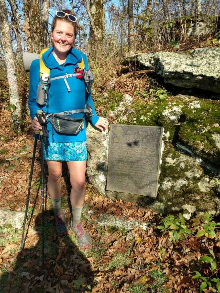
Though it was cold, the sun was shining on Springer Mountain when we arrived. I took my time soaking in the sun, the accomplishment of finishing my 15th thru-hike, and the happiness that permeates that mountain for me.
Springer was where I started my first thru-hike over twenty years ago. It’s where I finished my second FKT. It’s also where I began my Calendar Year Triple Crown hike in 2018. Hiking the Benton MacKaye Trail was not simply a lovely walk in the woods; in many ways, it was also a journey home.
Maps and Guidebooks
FarOut
The Benton MacKaye Trail is on FarOut, and this is the resource I used. In addition to maps, photos, waypoints, and a trackline, the user-updated comments were helpful for water sources, campsite selection, and resupply options. You can purchase it here.

While the BMT is well marked, guides and maps are especially helpful for potentially confusion junctions.
OnX
Detailed maps and descriptions of the BMT are also available from onX. Find more details here.
Maps and Guidebooks
The Benton MacKaye Trail Association (BMTA) produces and sells a complete set of maps and guides for the trail. Proceeds support trail maintenance. You can order them here.
Data Book
The BMTA also sells a data book, with campsites, services, distance, elevations, and more.

White diamonds and signage make the BMT well marked, though maps and guidebooks are still a good idea.
Getting There
By Plane
Southern Terminus
Fly into Atlanta and book a shuttle to Springer Mountain Trailhead (or Amicalola Falls State Park if you want to hike the approach trail).
Northern Terminus
Asheville, NC or Gatlinburg, TN, then book a shuttle (or hitch from Gatlinburg) to Baxter Trailhead in Big Creek Campground.

The author hiking on the BMT.
By Car
Northern Terminus
Baxter Creek Trailhead in Big Creek Campground, Great Smoky Mountains National Park 35.751149596085284, -83.1096299253194
Note: If you plan to park a car here, you will need a parking permit from the park. See permits tab for more information.
Southern Terminus
Springer Mountain Trailhead 34.63773451405418, -84.19539261534361
Detailed driving directions are on the Forest Service website here.
Note: The road to this trailhead is rough and may be inaccessible to low-clearance vehicles. The alternative is to start at Amicalola Falls State Park and hike the ~9-mile approach trail.
Bus and Shuttle Services
There are a variety of bus options for reaching the nearby cities, but the trailheads are remote. You’ll need to arrange for private transport to take you directly there. The BMTA website has a list of shuttle providers for the entire trail.
Additionally, many companies that service AT hikers will also be available to shuttle BMT trekkers. You can find more information here.
Trailheads
For thru-hikers, you can start at either Springer Mountain or Big Creek Campground. See the Getting There tab for detailed information. For those interested in doing sections of the trail, there are many trailhead options. The BMTA provides a comprehensive list, including coordinates, here.

Thru-hikers can begin either at Springer Mountain or at Big Creek Campground.
Regulations
Follow Leave No Trace Ethics
Outside GSMNP dogs are allowed on leash. They are not allowed inside the park.
Camping outside the park is dispersed. Inside GSMNP you must make permit reservations.
Resupply
While the BMT crosses quite a few roads, few readily take you to resupply points. The primary places to purchase supplies or send boxes are as follows (mileages below are northbound). This list is not exhaustive. For a complete listing of trail angels, shuttles, nearby accommodations, post office addresses, etc., visit the BTMA website here.
Cherokee, NC at mile 235.7 - This full-service town is six miles down US441
Fontana Marina at mile 192.3 - The Hike Inn is six miles east of Fontana Dam. They provide shuttles, accommodations, limited resupply, and hold maildrops for overnight guests. 3204 Fontana Road, Fontana Dam, NC 28733 Contact via phone (828) 479-3677 (landline) or email hikeinn@graham.main.nc.us.
Fontana Village Resort at mile 190.1 - There is a short side trail here to the resort where you can send mail drops, purchase supplies, or find accommodations. Call the Resort at (800) 849-2258 to verify the address and shipping details (there may be a fee). You can contact the Fontana General Store and Hazel Creek Outfitter at (828) 498-2211.
Tapoco Lodge at mile 180.3 - This is located on trail It is open for meals and holds mail drops for guests. Contact them via phone at (828) 498-2800 or email info@tapocolodge.com.
Unicoi Gap at mile 130.1 - This has a post office 3 miles away. You must call to arrange to send a box (423) 261-2286. Or, hitch 22.9 miles west to the full-service town of Tellico Plains.
Reliance Fly and Tackle at mile 110 - This is located on the roadwalk. They have a limited resupply and may hold mail drops. They also offer lodging. Reach them at (423) 338-7771.
Ducktown, TN, at mile 91.7, is 7.6 miles east of the trail and is a full-service town.
Blue Ridge, GA, at mile 49.6, is 4.5 miles off trail and is a full-service town.
Camping
GSMNP has an extensive set of regulations governing backcountry camping and food storage. You should familiarize yourself with them before you book your permits. Backpackers must stay at designated campsites while in the park. You will choose those sites in advance when you make your permit reservation. This can be done up to 30 days before your first night.
Depending on the time of year you plan to go, sites may be full since there are limited options where the BMT crosses through the park. As of 2024, fees are $8 per person/per night and are easy to book online.
Water Planning
Water is plentiful along the entirety of the route. I seldom carried more than 1 liter. Of note is that the water at the southern crossing of Georgia Highway 60 (NoBo mile 17.9) is non-potable. Check out our Best Backpacking Water Filters and Purifiers guide for tips on selecting the best filtration system for your needs.
Bears and Food Storage
Great Smoky Mountains National Park requires food and trash to be stored away from bears. This means using the provided cables at each campsite. You can read the regulations on their website. Bear canisters are not required.
The rest of the BMT is mainly on National Forest Land, where cables will not be provided. In this case, you should be prepared to use a canister or hang your food from trees using guyline. GSMNP has extensive information about traveling and hiking in bear country as well as their regulations.The National Forest Service guidelines can be found here.
Nobo vs Sobo
While the guidebook was written for northbound (NoBo) travel, I went Southbound (SoBo). The advantage to this direction is the ability to start with the section that requires permits so you can reserve them with accuracy before you leave home.
Gear Rentals
You can purchase or rent gear from Blue Ridge Hiking Company in Asheville, NC.
Gear List
Disclosure: The author is an ambassador for both Gossamer Gear and Montbell.
Tent
I used the Gossamer Gear The Two on this trip because I was hiking with a partner. I use Gossamer Gear's The One when I’m solo. Both tents are easy to set up, are lightweight, and are extremely roomy. In addition to above-average spaciousness, The Two has two entrances with large vestibules which makes sharing tent life with another human a lot easier.
See our Best Backpacking Tents guide for more recommendations.
Backpack
I used the Gossamer Gear Gorilla pack with modular Feedbag and Bottle Rocket Pocket added to the shoulder straps on this trip. The Gorilla has been my go-to pack for almost a decade. At 50L it can hold enough food for a five-day carry, but it isn’t so floppy when you’re carrying less that it’s annoying. Adding pockets to the shoulder straps helps improve accessibility of snacks, phone, and other frequent-use items.
See our Best Backpacking Backpacks guide for more recommendations.

The author poses with everything she packed for the BMT.
Sleeping Bag
I used the Montbell Seamless Down Hugger 900 #2 on this trip. It was too warm for most of the hike given the unusually hot and muggy November. However, it was perfect in the Smokies and on the last handful of nights when temps dipped into the 30s.
See our Best Sleeping Bags story for more recommendations.
Sleeping Pad
I carried a Montbell Alpine Pad 25 150 sleeping pad which was luxurious compared to my normal closed cell foam. I brought it anticipating colder overnights, but it wasn’t necessary for that. However, it did make some of the lumpier campsites far more comfortable.
See our Best Backpacking Sleeping Pads story for more recommendations.
Trekking Poles
I used the Gossamer Gear LT5 on this trip because they are supremely light, collapsible, and can be used to set up The Two tent.
For more recommendations, see our Best Trekking poles story.
Cooking System
I used the Soto Windmaster Stove and a Montbell 1L pot with the HumanGear GoBites Duo spoon/fork combo. This has been my standard set-up since my Calendar Year Triple Crown hike in 2018.
See our Best Backpacking Stoves story for more recommendations and our Best Cooking Pot section for our recommendations.
Headlamp
I carried the Black Diamond Spot headlamp which is affordable and relatively weatherproof. It’s my primary choice in headlamps since it’s bright enough to use for night hikes, without weighing a ton. See our recommendations in our Best Headlamps story.
Food Storage
For this trip, we used thin guyline to hang our food, as required by regulation. I also stored food in Loksak Odor Proof Bags overnight to deter rodents.
Water Filter
I used the Sawyer Squeeze on this trip since it’s easy to use, lightweight, and affordable. It is also the winner of Treeline’s Best Affordable Water Filter in the Best Water Filters and Purifiers for Backpacking guide.
What to wear
Shoes or Boots
I used the Altra Lone Peaks on this trip because they were the trail runners I had lying around the house.For more recommendations, see our Best Women’s Trail Running Shoes and Best Men’s Trail Running Shoes guides..
If you’d feel more comfortable in boots, check out our Best Hiking Boots story or our Best Lightweight Hiking Boots story.
A nice footwear compromise for this trip would’ve been hiking shoes, which are designed to feel like a trail runner but have stability more like a boot. See our Best Hiking Shoes story for footwear that has more durability and stability than trail runners.
Due to the varying weather conditions, it's a good idea to pack for wet, dry, cold, and warm weather.
Rain Jacket
I used the Montbell Storm Parka on this trip. While it’s much heavier than my normal rain jacket, I wanted something warm in case we got hit with an early-season snowstorm. While that didn’t happen, we did get hit by a hurricane and I was extremely grateful for the more overbuilt alpine shell.
For more recommendations, see our Best Lightweight Rain Jackets article.
Down or Synthetic Insulating Jacket
I used the Montbell Ignis Jacket on this trip. I did not use it for hiking, but I knew there might be some very cold nights. I wanted a dry insulating layer to wear in camp if everything else was soaked. I chose the Ignis over the Plasma (Montbell's other 1000-fill jacket) because it has a water-resistant shell, which performs better in the humid conditions of the Appalachians.
See our recommendations in our Best Synthetic Jackets article. If you prefer down for its better warmth-to-weight ratio, check out our Best Down Jackets guide.
Fleece or Midlayer
I used the Appalachian Gear Company All-Paca Hoodie for the first time on this trip. I was pleasantly surprised by its versatility, and was an immediate convert to their performance clothing.
Hiking Dress
I wore a thrifted sundress on this trip as I do on nearly all my hikes. It was comfortable and cute. No complaints.
Base Layer
I wore thrifted tights and a Montbell Super Merino Long Sleeve shirt in conjunction with the dress on cool mornings. I wore Cuddl Duds Fleece pants and a shirt for camp. These lightweight base layers are cheap and ensure that I always have something dry and warm for sleeping. For more recommendations, see our Best Base Layers guide.
Hiking Socks
I used the Point6 Light Cushion wool blend socks. These are my go-to socks for home and trail. Check our Best Hiking Socks guide for more recommendations.
Warm Hat
I used the Appalachian Gear Companie All-Paca Beanie because it came with the hoodie. It was surprisingly warm for its weight and when I needed more warmth I just pulled the hood of the hoodie up too.
Gloves or Mittens
I used a pair of Montbell Wool Knit Gloves and a generic fleece mitten as I do for most trips. I have Raynaud’s Syndrome, and I always have more than one hand covering in case one pair gets wet. For more recommendations on lightweight but warm gloves, see our Best Winter Gloves guide.

Warm clothes, mittens, and a hat are some helpful items in case the weather turns cold.
Miscellaneous Gear Items
First Aid Kit
I brought my standard kit: 0.85 oz Neosporin, 2 Imodium, 2 Benadryl, 2 Aleve, 4 Pepto Bismol Tabs, the smallest Rawlogy Cork Therapy ball, and a pair of Tick removal Tweezers. I carried an alcohol-based hand sanitizer, which could be used for sterilizing wounds as well.
For more tips on building a backcountry first aid kit, check out our Outdoor Items for an Emergency Preparedness Kit guide.
Sun Protection
I packed 2 oz of 30 SPF Sawyer Stay-Put Sunscreen.
Check out our guides on the Best Sunscreens for Your Body and Best Sunscreens for Your Face.
Pocket Knife
I packed a Swiss Army Classic knife.
Other items
I brought Montbell Light Down Pants with me for cold nights. I only wore them on the last 3 nights, but when I needed them, I really needed them. If I hiked this trail at this time of year again, I might bring a sleeping bag liner instead of the additional down layers.
I wore my Point6 Wool Neck Gaiter nearly every day – around my face and neck in the mornings and as a headband later in the day.
I carried Montbell Basic Down Footwarmers to wear in camp, and while not strictly necessary, I find it luxurious to put my feet into dedicated sleep socks and down booties after a long day – especially if I’ve had wet feet. For more recommendations, check out our Best Camp Shoes guide.
About the Author / why you should trust us
National Geographic Adventurer of the Year, Heather Anderson is the first woman to complete the Appalachian, Pacific Crest and Continental Divide National Scenic Trails each three times. This includes her historic Calendar Year Triple Crown hike in 2018 when she hiked all three of those trails in one March-November season, making her the first female to do so.
She holds self-supported Fastest Known Times (FKT) on the Pacific Crest Trail (2013) and Appalachian Trail (2015). She has logged over 47,000 foot-miles since 2003, including over 16 thru-hikes. She is also an avid mountaineer.
As a professional speaker, Heather speaks regularly about her adventures and the lessons learned on trail. She is the author of Thirst: 2600 Miles to Home (2019), chronicling her Pacific Crest Trail record, and Mud, Rocks, Blazes: Letting Go on the Appalachian Trail (2021) about her 2015 AT record. She also co-authored a guide to long-distance hiking preparation with Katie Gerber called Adventure Ready: A Hiker’s Guide to Training, Planning, and Resiliency (2022). You can find her online at Words From the Wild or follow her on Instagram and Facebook.


