Garmin inReach Mini 2 Satellite Messenger and GPS Long Term Review
THE SMALLEST, LIGHTEST, TOUGHEST TWO-WAY SATELLITE COMMUNICATOR

May 8th, 2024
Home > Gear Reviews > Electronics
Our Verdict
The Garmin inReach Mini 2 gets our vote as the smallest, lightest, toughest two-way satellite communicator in the outdoor world. These are the very same traits that have made it one of the most popular satellite communication, GPS, and SOS devices among outdoor enthusiasts all over the world, especially with weight-conscious backpackers and hikers. It’s the overall winner in our Best Satellite Messengers and Personal Locator Beacons guide.
The Mini 2, introduced in 2022, offers some significant improvements and additions over its predecessor, the Garmin Mini or Mini 1 as some refer to it.
The Mini 2 has a larger 1.75-inch color display, has TracBack routing with off-course visual and audible alerts, utilizes the user-friendly Explore App instead of the clunky Earthmate App the Mini uses, has longer battery life, and charges with a USB-C cord instead of USB.
All this comes along with the other standard features of the original Mini: two-way messaging, interactive SOS, weather forecasts, a digital compass, and on-screen tracking that allows routes to be created in the field without needing to sync the device with a smartphone.
While the Mini 2 doesn't have built-in maps or a map display like traditional GPS units or some other larger Garmin device like the 67i, it does its primary functions, two-way messaging, GPS tracking, and SOS emergency services via satellite communication very well.
Pairing the Mini 2 with a smartphone allows a user to access maps, aerial imagery, and the use of weather forecasts and navigational features on the phone’s larger screen.
• Read our latest explainer on how Garmin’s new subscription plans work!
We create reader-supported, objective gear reviews independently selected by our editors. This story may contain affiliate links, which help fund our website. When you click on the links to purchase gear, we may get a commission, without costing you an extra cent. Thank you for supporting our work and mission of outdoor coverage for every body! Learn more.
Specs

Weight: 3.5 oz
Size: 3.9" x 2" x 1"
Price: $400
Display type: Monochrome
Batteries: Rechargeable lithium-ion
Messaging: 2-way
Interactive SOS: Yes
Coverage: Global
Integration: Smartphone and certain Garmin wearables
Cell service required: No
Weather forecast: Yes
Digital compass: Yes
Altimeter: No
Basemap: There is a breadcrumb basemap with scant detail. There are no topographic maps of any kind on the Mini 2
Interface: USB-C
Water resistance: IPX-7 Which means it can be submerged in 3 feet of water for 30 minutes
Impact resistance: Yes, MIL-STD-810. This is a United States military testing standard that means an equipment's design will withstand the environmental conditions that it will be exposed to.
Wireless connectivity: Bluetooth, ANT+
Paid subscription: Required
Comparison Table
| DEVICE | MSRP* | WEIGHT (OZ) | SOS | WATERPROOF RATING | BATTERY LIFE |
|---|---|---|---|---|---|
| Garmin inReach Mini 2 | $400 | 3.5 | Yes | IPX7 | 14 days in 10 min tracking; 30 days in 30 min tracking |
| Garmin inReach Messenger | $300 | 4.0 | Yes | IPX7 | 28 days of battery life in 10-minute tracking mode |
| Garmin inReach GPSMAP 67i | $600 | 8.1 | Yes | MIL-STD-810 | 165 hrs. in 10 min. tracking mode; 425 hrs. in 30 min. mode |
| ZOLEO Satellite Communicator | $200 | 5.3 | Yes | IPX8 | 200 hours |
| Garmin inReach GPSMap 66i | $600 | 8.5 | Yes | IPX7 | Up to 35 hours |
Target Audience and Recommended Use Cases
The Garmin Mini 2 has the widest appeal to anyone who wants to have the basic services of a satellite communication device—two-way global communication with texting and email, tracking and location sharing, and an SOS capable of notifying rescuers from any location in the world—in a light and durable package that is smaller than the palm of your hand. Attached to a shoulder strap of a pack or PFD or carried in a shirt pocket, the wearer hardly feels its presence.

Although shown in this picture with its antenna in the open, the author carried the Garmin inReach Mini 2 fully zipped up inside the frame bag of his mountain bike. Because of improved satellite coverage and accuracy, the Garmin inReach Mini 2 can do navigation, messaging and all its other functions even when carried without a clear view of the sky. (photo by Dean Krakel)
This is especially appealing to adventurers who travel as light as possible and want to make every ounce count.
Pairing the Garmin Mini 2 to a smartphone and using the free Garmin Explore app, the device can be used for navigation using downloaded maps. The larger cell phone keyboard enhances all of the devices functions and makes it infinitely more friendly to use for communication and viewing weather forecasts.
What We Liked

Good news! If you ever need to know where you're at underwater, the Garmin inReach Mini 2 works in a watery environment. The author gave the MIni 2 a good dunking while attached the shoulder straps of a PFD in the icy water of Blue Mesa Reservoir near Gunnison, Colorado. The Mini 2 is waterproof for up to 30 minutes, which also means it can handle the rigors of being wet while doing watery adventures like kayaking, paddleboarding and sailing. (photo by Dean Krakel)
There’s everything to like about a lightweight unit that covers basic navigation, has the ability to do two-way communication, and can send out an SOS if there’s trouble. Because of the Garmin Mini 2’s small size and light weight, it’s unobtrusive and more likely to be taken along on trips. I carry mine (a Mini) on the dash of my truck because cell service is sometimes spotty to non-existent where I go on photo assignments.
In the winter I carry my Mini along with my avalanche safety gear. A few years ago a pair of skiers were killed in an avalanche on Death Pass near Crested Butte, CO near where I live.While they were carrying avalanche beacons, their families at home were alerted to the accident because one of them had a satellite communicator and their tracking had stopped.
The Explore app is easy to download and use. It is infinitely better than the Earthmate app used by the original Mini.
What Could Be Better
We don’t see much room for improvement in a basic unit such as this.
It’s interesting though that the Garmin Messenger, also in a small, lightweight package, can utilize cell service as well as satellites and switch seamlessly between the two depending on which is available. Why can’t the Mini 2 have that same connectivity?
Garmin’s new Etrex Solar GPS has unlimited battery power because, well, because it’s solar powered. We think this may be the future of all handheld satellite communication and GPS devices. This would be a really nice feature to be incorporated into, say, a Mini 3.
Features
2-way Satellite Messaging (including to other inReach devices)
The Garmin Mini 2 has two way messaging, both text and email, and can reach anyone on a user’s contact list, including people on other inReach devices. On the Continental Divide Trail my hiking partner and I used inReach devices to “talk” to each other during the times we got separated. We also used an inReach to contact a friend, on her email, to come pick us up on a Forest Service road after we’d gotten rattled during a particularly savage lightning storm.
Text messages
Text messages, as well as emails, are accessed through the Explorer app but go to the Garmin Messenger app. This is automatic, there’s nothing a user has to do. Recipients, including multiple recipients, can be selected in the message window on the Garmin Mini 2 and the message typed on the virtual keyboard, or it can be done a little more easily on a smartphone using the Explore App.

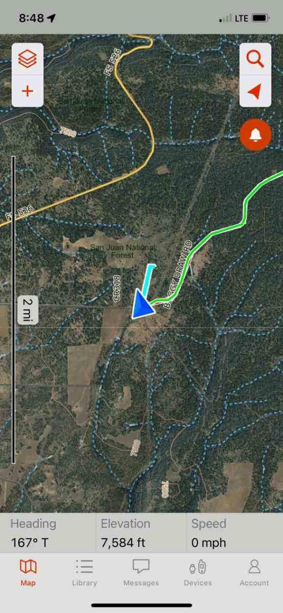
A detailed satellite picture on the Garmin Explore App when paired with the Garmin inReach Mini 2 shows the author's location while visiting friends near Cortez, Colorado. (photo by Dean Krakel)
Interactive SOS
The Mini 2 uses interactive SOS, meaning that once you press the SOS button located under a protective cap on the unit's right side you will also be able to communicate by text with the search and rescue personnel. This is helpful for rescuers because they’ll know the type of rescue that is needed, how badly injured or lost a user is, and other critical details. There’s an important difference in mobilizing an SAR team for someone lost or hypothermic or that someone has a twisted ankle, concussion, or a life threatening injury. This can mean the difference between sending a big team or just a few people or a horse team vs. a helicopter.
Signal Strength and Reliability
Because of the GNSS satellite system (see below) the inReach signal is strong and the connection fast, even with cloud or tree cover.
One feature I found useful is that the Garmin Mini 2, like other Garmin handheld devices, will track through a jacket or shirt pocket, or even the frame bag on a mountain bike. This comes in handy in cold weather. A technician at Garmin explained that the receiving capability on new GPS units is so sensitive that they don’t require being placed in an “open sky” position to operate. While an unobstructed view is optimal, the unit can function, like I said, in a shirt pocket or bike bag or in thick tree cover or at the bottom of a canyon.
Global navigation satellite systems/Multi-band GNSS
The inReach Mini 2 uses multiple Global Navigation Satellite Systems, (GNSS):
GPS
Galileo
QZSS
BeiDou
IRNSS
The sum total of which offer more accurate navigation, positioning, and weather forecasts anywhere in the world, using signals transmitted from these satellites.
Digital Compass
The Mini 2 has an electronic compass that can be accessed from the Navigation widget. The compass can give a reading even when the user isn’t moving.
Weather Forecast
Weather, both current and forecasted for your specific GPS location, are easily obtained on the Mini 2. My latest weather forecast, both current and future, took about 5 seconds on a clear sky day. On a cloudy day at the bottom of a canyon I’ve had to wait several minutes. The conditions have always been accurate for my location and the forecast was always right on.
Weather forecasts are treated as data and don’t count as messages. You can check the weather as many times as you wish without worrying about using up your text allowance, depending on what subscription you have and how many texts you may use.
Mapshare
When tracking is initiated a user can share their trip by pressing the Ok button and opening the options menu. Select your contacts. You can either type in a new contact on the virtual keyboard (a slow process) or add a contact by checking a box from your pre-loaded contact list (a much easier option and done on a computer or smartphone before a trip).

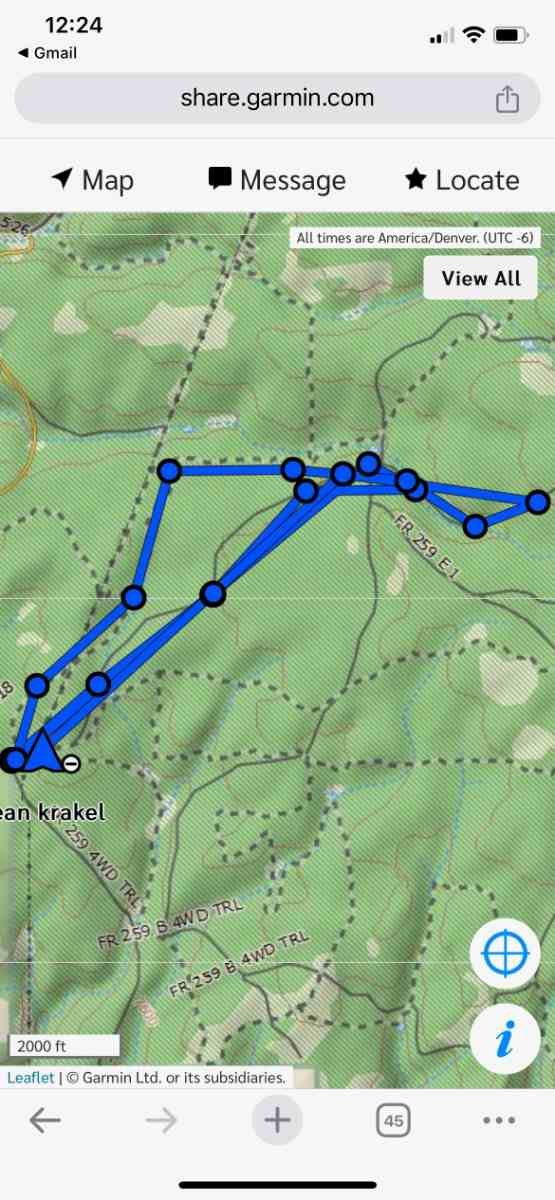
A MapShare map, with a different layer of mapping on the right, shows other views of the author's route on a mountain biking ride on the Garmin Explore App when paired with the Garmin inReach Mini 2. (photos by Dean Krakel)

Scrolling up opens the message window. I never put in a message as doing so is just too awkward on the Mini 2. I used the default message, “I’m starting my trip.” Hit the checkbox and select “send.” This is not always as easy as it sounds when using the small buttons on the Garmin MIni 2, but is doable. The process is much easier when the Explore app is used.
Livetrack
With the inReach Mini 2 a user can record their tracking points and transmit them. The tracking will appear on the Garmin Explore App and, by way of the MapShare pages, allow viewers to follow along in real time or, hey, past time as well.
Water and Impact Resistance
The Mini 2 is waterproof for 30 minutes when submerged in 3 feet of water, making it suitable for attaching to a PFD for packrafting, paddle boarding, or kayaking.. Additionally the unit is built to military standards for thermal, shock, and water performance. The device’s body is covered with a sure grip body made of plastic and rubber.

Garmin's inReach Mini 2 attaches easily the the shoulder straps of a PFD being worn by the author during a paddleboarding session on Blue Mesa Reservoir near Gunnison, Colorado. The Mini 2 is waterproof for up to 30 minutes at a depth of about 3 feet, which also means it can handle the rigors of being wet while doing watery adventures like kayaking, paddleboarding and sailing. (photo by Laine Walter)
While there are no specific ratings about the Mini 2’s impact resistance and despite being a tough and durable unit, there are limits to the abuse it can suffer. Mine has survived being dropped a few feet onto rocks. However if dropped 100 feet onto the bottom of a canyon floor, as one editor suggested, I think the odds are good that the Mini 2 would survive to navigate another day. But let's not do that okay? Lets keep the device tethered securely to ourselves or our gear.

To test how the Garmin inReach Mini 2 handles being placed underwater the author gave it good dunking while attached the shoulder straps of a PFD in the icy water of Blue Mesa Reservoir near Gunnison, Colorado. The Mini 2 is waterproof for up to 30 minutes, which also means it can handle the rigors of being wet while doing watery adventures like kayaking, paddleboarding and sailing. (photo by Dean Krakel)
Compatibility with Garmin Wearables
The Garmin Mini 2 can be paired with wireless sensors using ANT+ technology which allows connection with compatible units like heart rate monitors and some Garmin watches. This can provide enhanced tracking and data collection.
When paired with a Bluetooth heart rate monitor, the Garmin will monitor your heart rate in real time during your activities, allows a user to view and send messages directly from the watch, as well as access navigation data and allows the triggering of an SOS, all without needed to be hands on with the Mini 2 itself.
Bluetooth
Bluetooth is used for pairing the Mini 2 with a smartphone. Pairing with a smartphone allows you to easily compose and send messages, send an SOS, sync your contact lists, check the weather and send pre-set up check-in messages on the Garmin Explore app.
Battery Life
Stated battery life
According to Garmin the Mini 2, when set to 10 minute tracking mode, with a clear view of the sky, the battery can last up to 14 days.
Real-world battery life
In the real world? I fully charged the Mini 2 at 6pm on a Thursday night, left it on the dash of my truck 24/7 in cold temperatures with various weather and cloud cover conditions and used it on one to two hour hikes, bikes, and backcountry ski trips daily, set to the basic 10 minute tracking intervals. The Mini 2 ran out of juice on the following Wednesday morning at 8am.
Power-saving features
The Mini can utilize power saving by adjusting screen brightness, using a battery saver mode, and adjusting the GPS settings to less power draining modes. For example, you can track at 30-min intervals instead of 10-minute or 1-minute intervals or turn off tracking altogether.
Navigation and Mapping Features
Ability to add maps
The Garmin Mini 2 has a basic, detail-less bread crumb map on its navigation screen, however, when paired with the Explore App, high resolution maps can be downloaded onto your smartphone. These maps can be obtained with a subscription to Garmin Outdoor Maps+ which costs $49 per year. Garmin Outdoor Maps+ provides basic topo maps, enhanced topo maps, and satellite imagery.
Satellite imagery
High-resolution satellite maps can be downloaded with Outdoor Maps+ subscription.
Waypoints and Point-to-Point Navigation
The Garmin Mini 2 can do point-point navigation and waypoint navigation. From the “navigate” window a user can select to move to waypoints already saved. All you have to do is select that option and hit “go.”
Maps showing different layers of mapping and waypoints of the author's routes on the Garmin Explore App when paired with the Garmin inReach Mini 2. (photo by Dean Krakel)

You can also use a feature called Sight N’ Go by selecting such in the navigate window. You point the Mini 2 at an object and select “go” to start navigating towards it.
Waypoints and routes are easily created and can be saved for future reference.
Navigation from point-to-point can be done by using waypoints. Line of sight navigation is also possible by just pointing the unit at a geographical feature or in a particular direction and moving towards it.
TracBack
TracBack allows you to navigate back along a breadcrumb trail to your starting point along the same route you originally took just in case you need to retrace your route.

The Garmin inReach Mini 2, shown here in TracBack mode, has a black and white display screen and shows navigation "breadcrumb" style. TracBack gives the distance and direction back to your starting point and follows your original path, giving audible and on-screen warnings when you are off course. (photo by Dean Krakel)
Being one of those wanderers who truly are lost some of the time, I use this feature quite frequently. TracBack gives visual, which appears on screen, and audible cues (too high pitched for my poor hearing) when you are off course.
Courses
Courses and activities can be created, saved, and accessed on the Garmin Explore app. When tracking is activated, the Garmin Mini 2 records your trip as an activity. You can then view the trip details including distance, time, and route on a map.
Activities
Unlike some trackers like a Garmin watch, it doesn't have different activity settings. If it's left on, it'll track everything you do and put it under activities, including driving and walking. I turned mine off when I'm not actively doing activities outdoors.
User Interface
Ease of Use
With a little practice the Mini 2 is easy to use. The power button on the top right side speaks for itself. On. Off. Once the unit is powered on the left “up” and “down” buttons will scroll the user through the main menu. Both “up” and “down” take you to the same basic destinations: messages, tracking, navigation, weather, message check.
At each of those stations, pressing the okay button on the unit’s right side opens up the menu for that application. An easily followed menu, worked up and down with the left side buttons, and approved with the okay button, lets you choose what function you want to access. To back out of an application or return to the main menu all you have to do is hit the return button, which looks like a sideways U, located underneath the okay button.
The big, bold SOS button is located under a protective cap beneath the “return” button.
All of this can also be done through the Explore App. The Mini 2 is so easy to use though everything necessary for basic navigation, tracking, weather, and message checking can be done on the unit.
Garmin Explore App
The free Garmin Explore App can be downloaded onto a smartphone. This allows the phone's larger keyboard and maps to be used for messaging and navigating. Messages are easier to read, write, and send. Weather forecasts can be updated, preset messages created, an SOS can be initiated, tracking shared, and contacts created and updated.
Maps showing different layers of mapping and waypoints of the author's routes on the Garmin Explore App when paired with the Garmin inReach Mini 2. (photo by Dean Krakel)
With the Explore App you can sync data between the Garmin Explore website and the Garmin Mini 2, create and edit waypoints and routes, review recorded tracks and activities, download maps to your smartphone, and organize your data into collections.
The inReach Mini 2 can also be paired, by bluetooth, with an iPad allowing even a much larger screen for messaging and navigating.
Garmin Messenger Phone App
When paired with a smart phone and using the Garmin Explore App the Mini 2 utilizes Messenger to text and email.

A detailed topographic map shows the author's location while visiting friends near Cortez, Colorado on the Garmin Explore App when paired with the Garmin inReach Mini 2. (photo by Dean Krakel)
Buttons and Controls
Menu buttons are easy to use and intuitive. On the unit’s top is the power button, on the right side is an “okay” button, a “back” button, and, under an easily lifted plastic cover, the “SOS” button.
On the left side are “up” and “down” buttons that allow a user to scroll through the menu and move around on the onscreen map. After the initial learning curve (I already had a Garmin Mini) the buttons and what they do are easy to understand, although I have to admit I still find myself occasionally using the wrong buttons and having to backtrack to the main menu.
Screen Readability
The Mini 2’s screen is small but easy to read, visible even in dim light. The type face is large enough that I didn’t need my reading glasses.
Garmin inReach Subscription Plans
The Garmin website is easy to navigate. With recent updates to their subscription plans, we read the fine print and broke down the new plan options in our guide Explaining the New Garmin inReach Subscription Plans.

Comparison to Original inReach Mini
The Mini 2, introduced in 2022, offers some significant improvements and additions over its predecessor, the Garmin Mini. The Mini 2 has a larger 1.75-inch display, and has TracBack routing with off-course visual and audible alerts. The Mini 2 also has longer battery life, unlimited Cloud storage, uses the much friendlier Explore App, and charges and syncs with a USB-C charging cord. In contrast, the Mini 1 screen was only 0.9 x 0.9 inches.
Other Satellite Messengers to Consider
Garmin inReach Messenger Plus

This is the first satellite messenger from Garmin that can send photos, 30-second-long voice messages, and 1,600-character text messages from anywhere in the world — even without cell phone coverage.
It also has the other standard features, such as tracking, weather reports, and SOS messages.
For more, read our review of the Garmin Messenger Plus.
Compare prices of the Garmin inReach Messenger Plus

MSRP: $300
Weight: 4 oz
SOS? Yes
Waterproof rating: IPX7
Battery life: 28 days of battery life in 10-minute tracking mode
Garmin inReach Messenger has a small viewing screen. As a stand alone device, Messenger offers basic messaging—in other words you can send out a preset check-in message in which your GPS coordinates are embedded. It also offers tracking, TracBack, can get weather forecasts, and can send out an interactive SOS.
Compare prices of the Garmin inReach Messenger
To do anything more, Messenger needs to be paired with a smartphone and use the free Garmin Messenger App.
Messenger can use cell service as well as satellites and can switch between the two depending on connectivity. Messenger utilizes the full spectrum of Garmin’s Global Navigation Satellite Systems, (GNSS):
GPS
Galileo
QZSS
BeiDou
IRNSS
Together these satellite systems offer more accurate navigation, positioning, and weather forecasts anywhere in the world.
The Garmin Messenger’s battery life is rated at 28 days with a full sky view and a message or location (sent as a message) sent every 10 minutes.
Learn more in our in-depth review of the Garmin inReach Messenger.

MSRP: $200
Weight: 5.3 oz
SOS? Yes
Waterproof rating: IPX8
Battery life: 200 hours
Zoleo doesn’t have a viewing screen and is more focused on communication than navigation. Zoleo can only send and receive messages through the Zoleo smartphone app and has no navigational or trackback capability on its own.
Compare prices of the Zoleo Satellite Communicator
Zoleo users get a dedicated phone number with their subscription plan. I’m not sure how this figures into the device's usability.
Zoleo is heavier than the Garmin Mini 2.
Zoleo utilizes two satellites, GPS and GLONASS, so its navigational capability is less accurate then the inReach Mini 2, which utilizes 5 satellites. Zoleo does, however, offer communication through the use of cell towers as well as satellite.
Zoleo is less expensive than the Garmin Mini 2, costing around $200. However, the Zoleo subscription plan for service is more expensive than the Garmin subscription plans.
Neither of these units, the Garmin Messenger or the Zoleo Satellite Communicator, matches the Garmin inReach Mini 2 for capability, so let's not compare apples to mangos but apples to apples:
The Garmin inReach Mini 2 vs. the Zoleo Satellite Communicator
For starters both have to be paired with a smartphone to get beyond the most basic of their functions. The inReach Mini 2 does have a small viewing window that allows a user to view incoming or outgoing texts and check the weather.
Both Messenger and Zoleo utilize cell and satellite service and switch seamlessly between the two, depending on which is available.
Both can send SOS alerts and GPS locations. As a standalone device, Messenger can send check-in messages to notify contacts of trip progress, send location updates, start or stop tracking, and send an SOS.
Zoleo can do check-in messages and send an SOS using the built-in buttons.
Zoleo needs to be Bluetooth connected with the Zoleo App on a smartphone for two-way messaging, two-way SOS, to receive weather forecasts, or share your GPS location in any message.
When connected to a smartphone, Messenger can send preset messages and custom texts through its app.
Both Zoleo and Messenger use USB connection for charging.
Differences:
Zoleo costs around $200. The Garmin Messenger costs around $300.
The subscription plans are very different. Although both offer 3 subscription plans, Zoleo requires a 3 month subscription and has a startup fee.
With the least expensive plan and the startup fee, the cost, with location sharing on, would be $218.00. That would include 25 Satellite messages free and $0.50 for each additional. You cannot suspend your plan for 3 months. After that, a suspension costs $4.00 a month. SOS does not incur a charge.
There is no activation fee for the Garmin Messenger and the most economical monthly plan starts at $15 a month. There are 3 main plans, each with varying costs depending on tracking and messaging. There is no fee for canceling. There is no fee for preset check-in messages or for sending an SOS.
Depending on usage Zoleo has a battery life of 200 hours. The only way to check the battery's status is on the phone app.
Depending on usage, Messenger’s battery life is 28 days, which is about 600 hours. Messenger’s battery status can be viewed on the device's small window.

MSRP: $600
Weight: 8.1 oz
SOS? Yes
Waterproof rating: MIL-STD-810
Battery life: 165 hrs. in 10 min. tracking mode; 425 hrs. in 30 min. mode
The GPSMAP 67i is a Mini 2 on steroids. Everything from the screen size to its capabilities is larger. Both its weight and price are nearly double that of a Mini 2.
Compare prices of the Garmin GPSMap 67i
Everything from mapping to navigating to messaging can be done on the 67i’s big high resolution color screen with no smartphone connection required. Everything the Mini 2 can do, the 67i can do better.
The learning curve for the GPSMAP 67i is, however, quite a bit higher. For most users, who just desire a device that they can use to share their trip to the homefront, do two way communication, get weather forecasts, and call an SOS, the 67i is overkill.
Learn more about the Garmin GPSMap 67i in our full review.

About the author / Why You Should Trust Us
Dean Krakel is a three-time Pulitzer-prize-winning photojournalist, photographer, and photo editor whose work appears in National Geographic, Rolling Stone, Cowboys & Indians, High Country News, National Wildlife, Outside, Time, Yoga Journal, Newsweek, and Life magazines.
With over four decades of experience, his early dramatic documentary-style photographs of the Marlboro Man shot for the Leo Burnett Agency were seen worldwide.
Krakel is the author of three books: Season of the Elk, Downriver, and Krakel’s West. In 2015, Krakel left his newspaper career at the Denver Post to hike the 500-mile long Colorado Trail; a film about that hike—The Long Haul—won a Heartland Emmy Award.
Dean’s fine art prints are valued by collectors and have been exhibited in galleries in Jackson Hole, Wyoming, and Santa Fe, New Mexico. Large exhibition prints of his photographs are on permanent display in the Denver Justice Center. Dean is based in Crested Butte, Colorado.
You can read all of Dean’s Treeline Review articles on his author page.
Instagram: @dkrakel
Twitter: @dkrakel